
The Nantlle Ridge and Mynydd Mawr
Microgranite Intrusions and Folding on the Western Limb of the Snowdon Syncline.
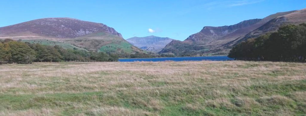
October – The Nantlle Ridge and Mynydd Mawr
View looking eastwards across the lake of Llyn Nantlle up the Nantlle Valley towards Snowdon, the distant peak beneath the small white cloud on the horizon. The broad, smooth, balding dome of Mynydd Mawr (2209ft/698m) sits on the nearer skyline towards our left, whilst the sharp crest line of the Nantlle Ridge runs along the skyline to the right. The Nantlle Ridge and Mynydd Mawr sit on the western margin of the huge down-fold of the Snowdon Syncline, whilst Snowdon itself sits in the middle of the syncline, near its southern end. The western margin of the Snowdon Syncline shows some similarities to the eastern and south-eastern margins that we saw in the Moelwyn and Cnicht Mountains, and in Moel Siabod, in previous pages. Like those mountains much of the lower slopes of the Nantlle Ridge, Mynydd Mawr and the Nantlle Valley are formed from the relatively easily eroded but steeply folded and tilted mudstones and siltstones of the Early Caradoc age Nant Francon Formation. This is because the outcrop of the Nant Francon mudstones dips down beneath Snowdon, and rises back up to the surface on this western side of the Snowdon Syncline, and also curves right around the southern end of the Snowdon Syncline, from the Moelwyn Mountains on its eastern limb. It then bends north-westwards across the Glaslyn Estuary north of Porthmadog, runs north-east all the way up the western margin of the Snowdon Syncline, through our viewpoint, and eventually forms the steeply eastwards dipping western limb of the Snowdon syncline in the western edge of the Snowdon Group, the Glyder Ranges and the Carneddau Mountains, which we saw earlier. However, as on the eastern margin of the Snowdon Syncline, these mudstones have been steeply folded and faulted and penetrated by large, bulb like intrusions of microgranite, formed as molten magma solidified at relatively shallow depths in the Earth’s crust, beneath the erupting volcanoes. One of these large intrusions forms the bald upper slopes of Mynydd Mawr (left) whilst the top of another is exposed in the lower slopes of the Nantlle Ridge to the right. The deep Nantlle Valley, which runs up towards Snowdon in the distance, was excavated much later, by valley glaciers in the Quaternary Ice Ages, whilst its glacial ice has now been replaced by glacial moraines and thick lake sediments after the ice melted.