
The Geoscience Wales Calendar 2015
GEOLOGICAL BACKGROUND TO THE 2015 GEOSCIENCE WALES CALENDAR:
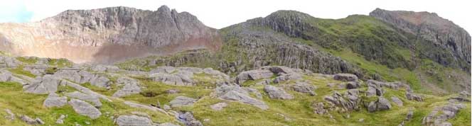
Crib Goch ridge and the valley of Cwm Uchaf, north-eastern Snowdon Massif. This landscape is composed of some of the highest, and therefore youngest, sequences of Ordovician volcanic rocks which are exposed in Snowdonia today (The Snowdon Volcanic Group). In the foreground and in the green tilted cliffs behind, coarse grained, thick beds of basaltic, volcaniclastic sediments of the middle part of this group (the Bedded Pyroclastic Formation) were erupted from the chain of volcanic islands onto Avalonia but were largely laid down in a marginal marine environment where they were re-worked by shoreline and marine processes. A very thick unit of massive, acid ash flow tuffs, the Lower Rhyolitic Tuff Formation, sits just beneath these rocks (out of sight here) and forms most of the steep cliffs south of Llanberis Pass, but also most of the peaks of Snowdon and Y Lliwedd to the south, as well as the cliffs of Cwm Idwal, in the Glyder Range to the north. The steep back wall of Crib Goch ridge in the background is formed by a probably contemporaneous rhyolite intrusion, which in some places clearly shows hexagonal ‘columnar jointing’ typical of slow cooling volcanic rocks in thick lava flows or in sub-surface intrusions. Several other rhyolite (and dolerite) intrusions also form some of the steepest cliffs in this part of the Snowdon Massif, whilst the greyish, sloping cliffs and orange coloured ridge crest on the right-hand skyline is formed by basalts and tuffs of the Upper Rhyolitic Tuff Formation, which is the youngest unit of the Snowdon Volcanic Group, and probably one of the last episodes of volcanism recorded in Snowdonia.
In last year’s Geoscience Wales Calendar we told the story of the geological and tectonic evolution of the whole of Wales over the last 600 million years. As part of that story we saw how the section of ‘continental’ crust that now underlies most of Wales, England and southern Ireland was originally formed as part of a small ‘micro-continent’ called Avalonia, which began to split and rift away from a much larger, southern hemisphere continent called Gondwana, probably around 600-500 million years ago. By Ordovician and Silurian times, Avalonia had rifted completely from Gondwana, creating a new ocean basin, the Rheic Ocean behind it, and was moving north-westwards, forcing the ‘oceanic crust’ of another ocean, the Iapetus Ocean, to be pushed downwards or ‘subducted’ deep into the Earth’s mantle beneath its leading edge. This subduction process melted the Iapetus ocean crust during much of the Ordovician Period, creating a chain of ‘island arc’ and later ‘back-arc or marginal basin’ volcanoes on the continental crust of Avalonia above that may have been similar to those on the Indonesian islands of Java or Sumatra today. The remains of these volcanoes, and the volcanic rocks and sediments which were laid down in the seas and on the islands built up around them, have now been revealed and exposed by later uplift and erosion across much of north-west Wales and in other parts of north-west Britain. In this year’s calendar we look more closely at the dramatic effects that these ‘tectonic’ and geological processes had on one area of Wales in particular, the Snowdonia National Park. This area is not only famous for it’s dramatic mountain scenery, but is now also widely acknowledged as one of the ‘classic’ areas of World geology for studying and understanding the processes of volcanism and continental rifting in a subduction zone, island arc and back-arc ocean basin setting.
INTRODUCTION: The Mountains of Snowdonia – Volcanoes and Sediments in an Island Arc.

Marine mudstones and siltstones of the Nant Francon Formation exposed in the slopes of Cnicht (rocks in left foreground) and the Moelwyn Mountains (dark mountains in the middle distance). The rocks seen here were originally laid down horizontally on the sea bed in a ‘marginal marine’ or ‘back-arc’ basin during the Caradoc Epoch of the Late Ordovician Period, but were then compressed, folded and metamorphosed to slates, in the mid-Devonian continental collision of the Caledonian Orogeny. They now dip quite steeply here (from 20 to 70 degrees to the north-west) and plunge towards us into the deep, green trench of the Croesor Valley (lower right) forming the southeastern limb of the so called ‘Snowdon syncline,’ a large structural down-fold which runs through much of north-western Snowdonia. After suffering further phases of compression, faulting and uplift in the Late Carboniferous to Early Permian Hercynian Orogeny, and then uplift and tilting associated with the opening of the Atlantic Ocean, these slates were eventually exploited on an industrial scale in the 19th and 20th centuries, as can be seen by the grey waste tips below the slate quarries on the upper slopes of the Moelwyn Mountains in the middle distance.
The originally sedimentary rocks of the Moelwyn Mountains and Cnicht also contain a number of igneous ‘intrusive’ rocks in the form of rhyolite and dolerite sills, as well as associated ‘extrusive’ volcanic rocks in the form of lavas ‘volcaniclastic’ tuffs and debris flow deposits (The Moelwyn Volcanic Formation). Although they are a relatively minor component here, these igneous and volcanic rocks were the early forerunners of much thicker and more voluminous sequences of volcanic rocks (and interbedded sediments) that were laid down slightly later in the Ordovician Period, and which now form most of the higher Snowdon, Glyder and Carneddau Ranges behind the viewer to the northwest. In fact, as we shall see in subsequent pages, there are actually several sequences of igneous and volcanic rocks exposed in Snowdonia, though these are not all of the same age. Some of the other, slightly older volcanic sequences form the Manod and Arenig Mountains (seen on the left-hand skyline), whilst others form the mountains of the Aran Fawddwy, Cadair Idris and Rhobell Fawr ranges, just out of view on the far distant skyline. This panorama also encompasses some of the oldest sedimentary rocks in Wales, the Cambrian age Rhinog and Barmouth Grit Formations, which were laid down in a marine basin that stretched across Wales before the Ordovician volcanoes began to erupt. However, these sedimentary rocks were also folded and uplifted by the Caledonian and later Orogenies, and now form the Rhinog Mountains of the Harlech Dome (far right skyline). It is the evolving story of these periods of volcanism, sedimentation and tectonics in Snowdonia that is the subject of this year’s 2015 Geoscience Wales Calendar.