
The Crafnant Country
The Final Act in Our Volcanic Story.
December – The Crafnant Country
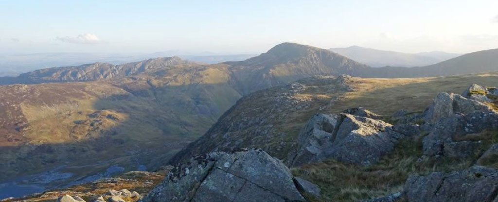
The ‘Crafnant Country’ lies at the north-eastern end of the Snowdonia Range and forms the eastern foothills of the Carneddau Range, which we examined earlier in this calendar. It consists of a number of south-west to north-east oriented mountain ridges, separated by deep, elongated lake basins. These are filled by the lakes and reservoirs of Dulyn, Melynllyn, Llyn Eigiau, Llyn Cowlyd, Llyn Crafnant and Llyn Geirionydd. The photo shows the southern end of Llyn Eigiau (lower left) whilst the large reservoir of Llyn Cowlyd lies just over the grassy ridge at the upper left edge of the picture. In the foreground is the spectacular dolerite intrusion of Craig Eigiau rocks (2411ft/735m) which also extends along the steep cliff line to the summit in sunlight, just beyond. Above that is the broad dome and north eastward dipping rock bands of Pen Llithrig y Wrach (around 2590ft/790m) whilst the obvious north-east dipping rock units of the Creigiau Gleision Ridge (2224ft/678m) extend above the green grassy ridge to its left. Above Creigiau Gleision we can just see the distant hazy summits of the Arenig Mountains, discussed much earlier, and on the right-hand skyline the broad, gentle ridges of Moel Siabod and the Moelwyn Mountains, the south-eastern rim of the Snowdon Syncline. The rocks of the Crafnant Country represent the final stages of volcanism in Snowdonia and are probably the north-eastward equivalents of the Snowdon Volcanic Group, which we saw earlier in the Snowdon and Moel Hebog Massifs to the south-west. The Crafnant Volcanic Formation forms most of the Crafnant Country, and consists of up to three units of acid ash flow tuffs, basaltic tuffs and hyaloclastic tuffs (volcanic ash deposited under water) which, along with the even later Dolgarrog Volcanic Formation to the north-east, represent the final volcanic outpourings in Snowdonia. After this, most of the volcanic rocks became submerged beneath deeper marine sediments (the black mudstones of the Cadnant Shales and Conwy Mudstones) which were laid down in the last stages of the Ordovician Period, the Ashgill Epoch. After this, most of Wales remained submerged beneath the sea, which was then filled with turbidite sediments in the Silurian Period. At this point our story of volcanoes in Snowdonia comes to an end, although it was the later folding, uplift and erosion of this part of Britain in the subsequent geological periods, and deep erosion by the valley and mountain glaciers of the Quaternary Ice Age, that actually formed the spectacular mountains of Snowdonia that we see today.