
The Aran Mountains and the Bala Fault
Uplift, Tilting and Faulting on The Eastern Edge of the Harlech Dome
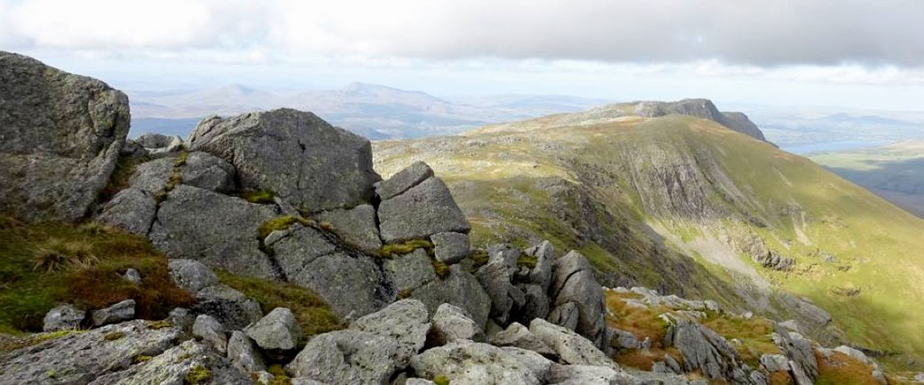
April – The Aran Mountains and the Bala Fault
Looking north along the crest of the Aran Mountains from the summit of Aran Fawddwy (2971ft/907m) across the green slopes and gullied cliffs of Erw y Ddafad-ddu (2861ft/872m) to the dark crags of Aran Benllyn (2903ft/885m). Bala Lake lies to the right, in the deep, linear valley of the Bala Fault Zone, which stretches away in the distance to the northeast. The twin summits of the Arenig Mountains, Moel Llyfnant (2461ft/751m) and Arenig Fawr (2801ft/854m) which we will examine on the next page, lie on the skyline to the left, above the dark rocks of Aran Fawddwy in the foreground. The Aran Mountains lie on the eastern margin of the Harlech Dome structure, which we have examined in previous pages, but they are still affected by its overall dome structure, and, like most of the other mountain groups of Snowdonia are still rugged mountains because they are formed of the relatively hard and resistant volcanic rocks (and their associated igneous intrusions) erupted onto the Avalonian micro-continent in the Ordovician Period. The boulders in the foreground above, and the outcrops along the summit crest stretching north to Aran Benllyn, are composed of the uppermost unit of the Aran Volcanic Group (the Aran Fawddwy Formation) which is the northward continuation of the volcanic rocks seen in the upper part of Cadair Idris, on the previous page. In Cadair Idris these rocks dipped south-eastwards, but here they dip steeply to the east-southeast at up to 60 degrees, as can be seen by the very steep dip down to the right of the overlying (and therefore younger) Ceiswyn and Nant Hir Mudstones in the sunlit gullies and smooth, green hill slopes of Erw y Ddafad-ddu in the middle distance. The eastward dip of these rocks is a result of tilting, faulting and folding on the eastern margin of the Harlech Dome in the mid-Devonian Caledonian Orogeny, and by later phases of compression and uplift in the Late Carboniferous/Early Permian Hercynian Orogeny and Late Mesozoic to Tertiary tilting and uplift associated with the opening of the North Atlantic Ocean province.