
The Core of the Harlech Dome and the Rhinog Mountains
Sedimentation in a Submarine basin – Before the Volcanic Storm.
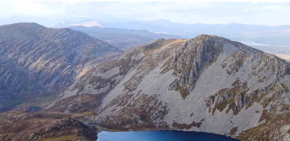
January – The Core of the Harlech Dome and the Rhinog Mountains
Looking north from the summit of Y Llethr to the peaks of Rhinog Fawr, 2362ft/720m (left) and Rhinog Fach, 2336ft/712m (right) in the core of the ‘Harlech Dome’ structure of the Rhinog Mountains. The Moelwyn Mountains and Cnicht, which we saw earlier, lie in sunshine in the distance, with the Snowdon and Glyder ranges in cloud on the far left-hand skyline, and Moel Siabod and the Manod Mountains in shadow along the right-hand skyline, above Trawsfynydd Lake. We will visit and investigate the geology of all these mountains over the following pages! The thick, multiple beds of coarse grained grits and ‘greywacke’ sandstones (the Rhinog and Barmouth Grit Formations) which form the Rhinog Mountains we see here, were initially deposited as fluvial, deltaic and shallow marine sediments around the margins of a deep marine basin that lay across central Wales in Cambrian times. As they accumulated around the basin margins these sediments were periodically shaken by earthquakes, or simply collapsed under their own weight, and slumped or flowed down the submarine slopes into the deeper parts of the basin, forming plumes of suspended sediment known as ‘turbidity currents’. These sediments eventually settled out in the deeper parts of the basin to form thick layers and fan shaped wedges of often poorly sorted sandstones called ‘turbidites’. Gradually, through later Cambrian, Ordovician and Silurian times this deep marine basin became filled with sediments, which were later compressed by the mid-Devonian Caledonian Orogeny to form the dome shaped structure of the Harlech Dome. This structure was later unroofed and exposed to erosion by further uplifts associated with the opening of the adjacent Atlantic Ocean, Irish Sea and Cardigan Bay basins, so that the thick beds of resistant grits and sandstones now form the spectacular terraced escarpments of the Rhinog Mountains we see today. However, the deeply scalloped, lake filled basins beneath some of the cliffs and summit ridges were eroded out much later, by the glaciers of the Quaternary Ice Ages. All of these sedimentary rocks then, were laid down before the main period of volcanic eruptions began, which is thought to have commenced with the volcano of Rhobell Fawr, which we will examine on the next page.