
The Snowdon Group
Thick Sequences of Volcanic Rocks Erupted along Crustal Fractures and Preserved Within a Caldera.
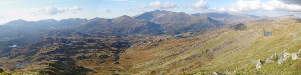
November – The Snowdon Group
The above composite panorama of the eastern side of the Snowdonia Mountains from the summit of Cnicht (2265ft/689m) brings together much of the story of the formation and preservation of the later stages of volcanism in an island-arc and/or back-arc setting that we have illustrated and discussed over the preceding pages. The panorama extends from the broad, dome like summit of Moel Hebog (far left skyline peak) along the knobbled crest of the Nantlle ridge (which we saw from the other side in the previous page) to the deeply scalloped and higher summits of the Snowdon Group in the centre. To the right again the broad summits of the Glyders and the Carneddau Range sit in dappled cloud to the north-east. At the extreme right, the pyramidal mountain tipped by a cloud shadow is the isolated peak of Moel Siabod, which we saw several pages ago. The whole of the series of mountains that we see here today then, sit within the deep, south-west to north-east oriented down-fold of the Snowdon Syncline. Although the rocks which form these mountains are now uplifted and are being actively eroded, it was this combination of down-folding, plus their relative resistance to erosion which meant that the thick sequences of volcanic rocks, and their associated igneous intrusions, have largely remained to form the spectacular mountain range that we see today. However, on top of this general ‘preservation’ within the Snowdon Syncline, additional volcano-tectonic factors were also probably at work. Although the Carneddau and Glyder Ranges to the north are mainly formed from the Llewelyn Volcanic Group, the earliest and lowest of the two final sequences of volcanic rocks in Snowdonia, the rocks of the second and youngest of these two events, the Snowdon Volcanic Group were further preserved here, in the southern end of the syncline, because they were formed within the collapsed and subsided basin of a large volcanic ‘caldera’. This down-faulted, volcanic crater like structure now preserves the thick volcanic rocks and igneous intrusions of the Snowdon Volcanic Group in an oval or bowl shaped structure which extends from the summit of Moel Hebog, at its southern limit, to the line of the Llanberis Pass, which forms its northern limit, just north of the Snowdon Massif. The panorama above also clearly illustrates the steeply westward dipping beds of all the rocks along the foreground hillsides, which dip into the core of the Snowdon Syncline, and therefore form its south-eastern limb. The deep valley just beyond them, along the foot of the Snowdon Massif, is the Nant Gwynant Valley. This valley is underlain and closely paralleled by a series of long south-west to north-east oriented fractures, the Glaslyn-Nantmor Fracture Zone, which, along with the Cwm Pennant Fracture Zone beyond Moel Hebog, is believed to have formed the down-faulted margins of the Snowdon Caldera basin. They may also have been part of the crustal fracture systems that allowed some of the Snowdon Volcanic Group lavas and intrusions to reach the surface.