
The Moelwyn and Manod Mountains
Folding and Volcanism Exposed on the North-western Margin of the Harlech Dome
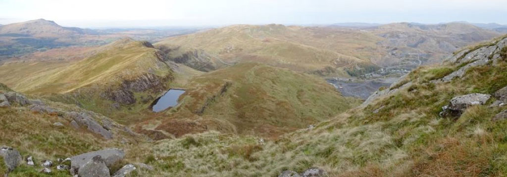
June – The Moelwyn and Manod Mountains
The photo-panorama above was taken looking north-eastwards from the northern slopes of Allt Fawr (2290ft/698m) the easternmost and highest summit of the Moelwyn range of mountains, which lie to the northwest of the slate mining town of Blaenau Ffestiniog. On the far right distant horizon we can see the blue-grey summit pyramid of Arenig Fawr, which we discussed on the previous page, which is formed from the northern limits of the Early Ordovician, Llanvirn to Early Caradoc age Llyn Conwy volcanic rocks; part of the Aran Volcanic Group. Just in front of Arenig Fawr, and closer to us, are the twin, mainly grassy, green slopes of the Manod Mountains, crowned by Manod Mawr at 2168ft/661m. The two main summits of the Manod Mountains are formed by steep, bulbous domes of quartz latite, which are igneous intrusions that pushed their way up through the overlying marine mudstones and siltstones (which are now called the Nant Francon Formation) and probably represent the exposed tops of molten magma domes that would have supplied lava to the nearby volcanoes. Other extrusive volcanic rocks and rhyolitic lava domes also occur just to the east of the Manod Mountains, forming the Rhiw Bach Volcanic Formation. However, these rocks occur within the lower part of the Nant Francon Formation, and are therefore thought to be stratigraphically slightly lower and older than the Llyn Conwy volcanics of the Aran Volcanic Group that we saw in the Arenig Mountains, and in the equivalent upper parts of the Aran and Cadair Idris mountains around the southern and eastern rim of the Harlech Dome. It was the marine mudstones of the Nant Francon Formation, that were metamorphosed to slate by the heat and pressure of the mid-Devonian Caledonian Orogeny, that are being quarried extensively in the valleys around Blaenau Ffestiniog, as can be seen here at far right. The rocks in the green mountain ridges above the Crimea Pass road, in the centre distance, and above the small damned lake (Llyn Iwerddon) are also composed of the Nant Francon Formation slates, and also contain later intrusions of dolerite (as in the small cliffs above the lake). All of these rocks can now be seen to be dipping to the north and north-west here, because we are now on the northern rim of the Harlech Dome structure. However, they are also starting to dip into the south-eastern limb of the large Snowdon Syncline, a huge down-fold structure which lies to our left (i.e.to the north-west). In fact, on the far left skyline, the mountain of Moel Siabod (2861ft/872m) is also largely composed of mudstone and siltstone, along with numerous dolerite intrusions, but this mountain, and the Dolwyddelan valley at its foot takes us into the Snowdon Syncline, and onto the next page.