
Moel Siabod and the Dolwyddelan Valley
Igneous Intrusions and Folds on the South-eastern Limb of the Snowdon Syncline
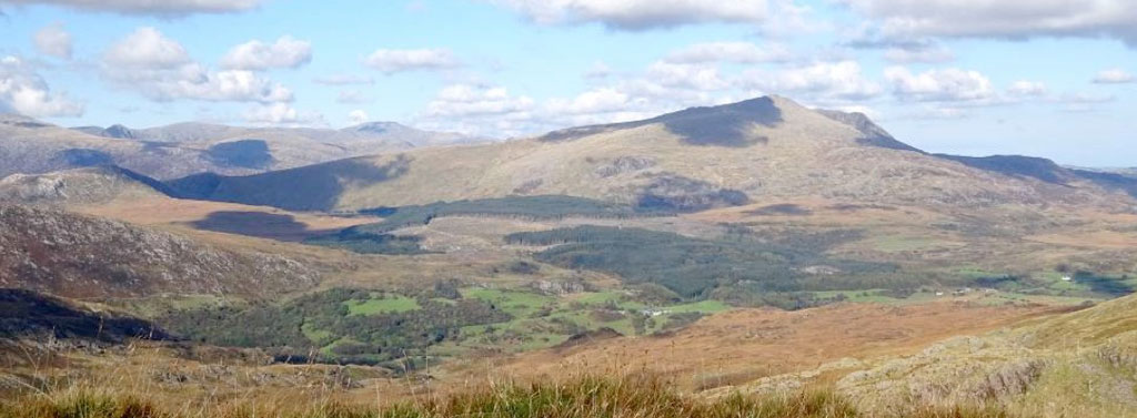
July – Moel Siabod and the Dolwyddelan Valley
The distinctive 2861ft/872m summit of Moel Siabod, often seen in the distance to the north on previous pages, lies here under the patch of cloud on the right-hand skyline. The valley running along its base is the Dolwyddelan Valley, whilst the mountains along the far left skyline are the eastern end of the Glyders Range, with Tryfan (3010ft/915m) peeping over their shoulder. The long whaleback domes of the Carneddau Range (Carnedd Dafydd, 3400ft/1044m and Carnedd Llewelyn, 3484ft/1064m) stretch out along the horizon, just to their right. Moel Siabod is mainly composed of mudstones, siltstones and sandstones, along with relatively thin beds of volcanic rocks and igneous intrusions, similar to those of the Nant Francon Formation we saw in the Moelwyn Mountains and Cnicht, just to the south. However, these sedimentary rocks are actually younger than those of the Nant Francon Formation and therefore further up in the geological sequence. They consist of shallower marine sediments (the Cwm Eigiau Formation) that show significant local re-working by fluvial, coastal and shallow marine currents. It is into this shallower environment that the next two major episodes of island-arc/back-arc basin volcanoes erupted, but this time they occurred mainly in north-western Snowdonia. The first of these episodes is called the ‘Llewelyn Volcanic Group,’ a thick series of volcanic rocks and associated intrusions which erupted on top of and into the Nant Francon Formation. These rocks now form most of the eastern summits of the Glyders and Tryfan seen here, which mainly consist of a thick, upper unit, called the Capel Curig Volcanic Formation. The western ridge line of the Carneddau Mountains on the distant skyline is also largely formed by this upper unit, but also exposes the lower units of the Llewelyn Volcanic Group, the Foel Grach Basalt, Conwy Rhyolite and several large igneous intrusions, which probably represent the volcanic sources. The Llewelyn Volcanic Group was then followed by deposition of the Cwm Eigiau Formation sediments, which we see here in Moel Siabod, although thick, erosion resistant dolerite intrusions actually form most of its east face and sharp summit ridge. The upper part of the Cwm Eigiau Formation was eventually overlain by the second (and therefore younger) major phase of volcanism, the Snowdon Volcanic Group, which we will see in later pages. Again, all of the rocks in the mountains we see here were subsequently compressed into open, kilometre scale folds by the mid-Devonian Caledonian Orogeny (very well seen in the Glyder Range, which we will also visit later) but this compression also produced a much larger scale down-fold, the Snowdon Syncline, which is at least 60km long and 40km wide!