Digital Outcrop Models of Hydrocarbon Reservoir Analogues: An example from Alderley Edge, Cheshire
Date: Thursday, 20th February 2014
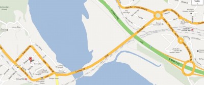
This presentation will take place at the Royal Cambrian Academy headquarters in Crown Lane, Conwy at 6.30pm. Refreshments from 6.00pm.
Speaker Overview:
Dr David Hodgetts – Senior lecturer in Petroleum geology and Reservoir Modelling. Basin Studies and Petroleum Geoscience Group.
David received an honours degree in Geology from Durham, followed by a Computing in Earth Science MSc from Keele University where he stayed on to undertake a PhD in 3D numerical modelling of continental lithospheric deformation. After a short post doctoral research position at Keele working on 3D structural restoration algorithms he moved to Liverpool to join the Strat Group, working on a diverse range of projects both subsurface and fieldwork related. He joined the University of Manchester in 2003, and is currently a Senior Lecturer in Petroleum Geology and Reservoir Modelling.
David has 18 years’ experience of working on petroleum industry projects ranging in scope from forward modelling, geological software development, seismic interpretation, field mapping and reservoir modelling primarily focussing on siliciclastics. His research over the past 10 years has focussed on the application of digital data acquisition techniques, in particular terrestrial laser scanning (lidar) to field geology. This research has focussed on outcrop description and extraction of geostatistical data to assist in subsurface reservoir characterisation. In order to achieve this he has developed software called VRGS (Virtual Reality Geological Studio) to facilitate the processing, interpretation and modelling of lidar and other digital outcrop data types.
Abstract:
Lidar mapping is rapidly becoming a regular addition to the field geologists toolkit. Using Lidar data it is now easy to make photorealistic models which involve producing a triangulated irregular network (TIN) or mesh of the point cloud, and then texture mapping digital images onto the mesh via projective texturing techniques. This approach produces visually pleasing models which are easy to interpret, however this is only the case if the features of interest are clearly visible in the digital photograph, which in rocks of fairly uniform colour may not always be the case.
The high resolution nature of lidar derived digital outcrop models facilitates the generation of surface attributes (such as curvature, co-planarity and roughness for example) which may be used to highlight features not easily seen in the photo-realistic model. These surface attributes not only make manual interpretation of the data easier, but facilitate the development of more automated mapping and tracking tools, which are essential in the large datasets provided by terrestrial and airborne laser scanning.
The Sherwood Sandstone Formation (SSF) is an important economically in the UK as both aquifers and hydrocarbon bearing reservoirs. In this study digital outcrop modelling approaches integrated with traditional fieldwork aims to shed new light on this important geological group. Lidar data collected from extensive mine workings in the Alderley Edge are used to build digital outcrop models allowing accurate mapping and measurement of key stratal surfaces, structure and sedimentology, with a focus on understanding fault geometry, and fracture distribution in relation to those faults and to the mechanical stratigraphy of the SSF.
The Alderley Edge Mines themselves are distributed over an area of 1.5km x1.0 km approximated with around 16km of passages and caverns down to a depth of 60m. The mines (originally used for minerals such as copper, lead and cobalt) are cut through the Sherwood Sandstone offering exceptional and unparalleled 3D exposure of the Sherwood sandstone.
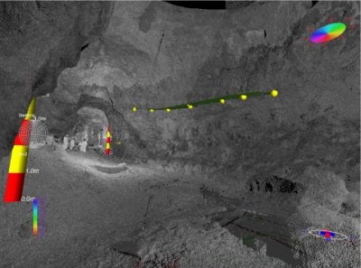
- 1 An view of a Lidar data based model from the Alderley Edge Mines. The image colour shows the reflection intensity of the laser. Several scans are merged together to form this model.
Recent Publications
- Hodgetts, D., in press. Laser Scanning and Digital Outcrop Geology in the Petroleum Industry: A review. Marine and Petroleum Geology.
- Rarity, F., van Lanen, X.M.T., Hodgetts, D., Gawthorpe, R.L., Wilson, P., Fabuel Perez, I., Redfern, J., 2013. Quantifying depositional elements: LiDAR-based digital outcrop datasets for integrated sedimentological analysis, in: Martinius, A.W., Howell, J.A., Good, T. (Eds.), Sediment-Body Geometry and Heterogeneity: Analogue Studies for Modelling the Subsurface. Geological Society of London.
- Seers, T.D., Hodgetts, D., 2013. Comparison of digital outcrop and conventional data collection approaches for the characterization of naturally fractured reservoir analogues, in: Spence, G.H., Redfern, J., Aguilera, R., Bevan, T.G., Cosgrove, J.W., Couples, G.D., Daniel, J.-M. (Eds.), SP374 Advances in the Study of Fractured Reservoirs. Geological Society, London, Special Publications.
- Fabuel-Perez, I., Hodgetts, D., Redfern, J., 2010. Integration of digital outcrop models (DOMs) and high resolution sedimentology – workflow and implications for geological modelling: Oukaimeden Sandstone Formation, High Atlas (Morocco). Petroleum Geoscience 16, 133-154.